
My new husband and I (and our fur-baby Rhea) just recently moved from the backwoods of West Virginia to the Bay Area of California. Although it might be daunting for some newlyweds in their early twenties, we made an adventure out of it. If we had to drive across the country anyway, why not see everything we can along the way?

Road tripping on a budget
When I was planning our route, I had some specific landmarks in mind (Yellowstone, Mt. Rushmore, Crater Lake) that I wanted to visit. Here are some tips for seeing everything without breaking the bank:
1. Stay in campgrounds - Campsites are usually a lot cheaper than hotels, and in my opinion they're a lot more fun! To help me find budget campgrounds near our route, I got the book "Guide to Free and Low-Cost Campgrounds" -- everything in the book is under $12! (For those of you thinking about buying the book, I'll warn you to read the descriptions carefully; some prices listed are only if you're a senior, resident of the state, etc.) Unfortunately due to weather, we weren't able to stay at all the campgrounds. In these cases, my Orbitz app on my phone came in handy -- I simply booked the cheapest (pet friendly) room at our destination a few hours before our arrival.
2. Stock a cooler with food - We had cereal/granola bars for breakfast and kept lunch meat, bread, etc. to make sandwiches for lunch. For dinner, we either cooked hot dogs/hamburgers over a campfire or fired up our propane stove.
3. Bring friends - Not only is it more fun to share the experience with friends, it's cheaper when you can split the gas/lodgings between more people!
4. Find free attractions - I also had the book Let's Go Roadtripping USA: On a Budget that showed a lot of the attractions along our route, with the prices listed. We stopped by many free (or almost free) museums and roadside attractions that were definitely worth our time.
5. Check gas prices - Gas prices generally increase going east → west, so we made sure to fill up on gas before entering the next state. You can also check prices using the GasBuddy app, or if you're using Google Maps, it will show you gas stations along your route with prices.
6. Track your spending - This is a habit I have for all my trips, to make sure we don't get carried away with souvenirs and eating at restaurants.
*7. Buy an America the Beautiful pass - Depending on how many national parks you plan on stopping at, it might be worth it to buy this pass (details here), an $80 ticket to get into all the national parks for a year (it is important to note that the pass is not good at Mt. Rushmore because there is not an entrance fee, just a parking fee).
Adventure is out there
For anyone else planning a cross-country trip, here are some general things to keep in mind:
1. Use your smartphone, but don't forget to look around. Watch the roadsigns for scenic overlooks and billboards for anything that might look interesting. Some apps that I used a lot on our trip were: The Weather Channel, Orbitz, Trip Advisor, GasBuddy, and Rest Stops. AAA also has a nice app with all their maps available.
2. Be open to change. We changed our itinerary several times over the course of the trip--deciding to drive more one day so we could drive less the next day, etc. The weather can also cause you to change your plans, so stay flexible.
3. Factor in time to see the sights, not just the driving time. Taking time to stop and see everything (and take scenic byways) takes extra time, but it's worth it!
4. Don't get in a hurry. There is so much to do and see across America, take as much time as you can!
Our Trip
Here was the route we took from West Virginia to California:

Day 1:
Franklin, WV → Parkersburg, WV
194 miles
Red Roof Inn
Day 2:
Parkersburg, WV → Howell, MI
332 miles
Brighton State Recreation Area
Despite the road work, this was a beautiful drive and a beautiful campground. There was a lake inside the campground, and plenty to see.


Day 3:
Howell, MI → Mackinaw City, MI
259 miles
Days Inn Lakeview
The thunderstorms caused us to find a hotel for the night; we found a room for only $55, and what a great room! The hotel was right on Lake Huron. Since we didn't have to spend time setting up camp, we were able to drive around Mackinaw City. It's a very cute lake town known for its fudge; Brian got a large bag of saltwater taffy while I tried free samples of fudge. We also visited a couple lighthouses and got a good view of the Mackinac Bridge.


Day 4:
Mackinaw City, MI → Wisconsin Dells, WI
400 miles
Rocky Arbor State Park
*Cross into central time zone
The upper peninsula of Michigan is absolutely beautiful! The drive along Lake Michigan really shows you how enormous the Great Lakes are. We had to take a couple detours when the roads we were supposed to drive on were closed. In the Dells, we were able to get some Wisconsin cheese :)


Day 5:
Wisconsin Dells, WI → Sioux Falls, SD
384 miles
Red Roof Inn
Lesson of the day: Minnesota is boring. Drove over the Mississippi River, and thunderstorms caused us to get a hotel room.
Day 6:
Sioux Falls, SD → Rapid City, SD
387 miles
Super 8
*Crossed into mountain time zone
Another bad day for weather, but overall a beautiful drive. Over 300 miles away from Wall, SD, we started seeing signs for Wall Drug. We drove over the Missouri River, and saw lots of wildlife (mostly prairie dogs). Despite the clouds, we had to take the scenic byway through Badlands National Park -- absolutely gorgeous. And right inside the park were some Dall sheep to welcome us! After that, we had to stop in Wall to see Wall Drug. We also ventured a few miles north of Rapid City to see the Petrified Forest of the Black Hills (definitely recommend). Brian convinced me to walk through Rapid City (the "city of presidents") to see statues of all the presidents. I'm glad he did -- we ended up doing a scavenger hunt and winning "presidential sodas"!


Day 7:
Rapid City, SD → Cody, WY
411 miles
Ponderosa Campground
On this leg, we saw Mt. Rushmore, Crazy Horse, and of course every rock shop and museum in between. We drove through the Bighorn National Forest, and saw a moose!


Day 8:
Cody, WY → Bozeman, MT
250 miles
Sunrise Campground
Today was an incredibly hot day, but a beautiful drive through Yellowstone. We were able to see a few buffalo and lots of hot springs. Unfortunately we didn't see Old Faithful because we didn't want to wait an hour. It started raining near the end of our drive, but our destination was dry enough for us to stay at a campground.


Day 9:
Bozeman, MT → Missoula, MT
207 miles
Super 8
Way too hot for camping in Missoula. Got to see a lovely friend!

Day 10:
Missoula, MT → Hermiston, OR
369 miles
Motel 6
*Crossed into pacific time
Another day too hot for camping. We drove through Idaho and down through Washington.


Day 11:
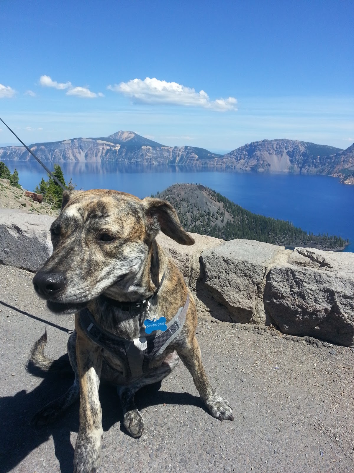
Hermiston, OR → Crater Lake, OR
371 miles
Mazama Campground
We drove down through central Oregon (such a beautiful drive) and were able to spend a lot of time at Crater Lake, even enjoying the sunset on the rim. We also got some good views of Mt. Hood and the Three Sisters.


Day 12:
Crater Lake, OR → Ft. Bragg, CA
392 miles
Hidden Pine Campground
On this leg, we stopped at a nice rock shop (Chapman's Gem & Mineral Shop near Fortuna, CA). We also drove through Redwood National Forest. Important lesson: Highway 1 is not for people who get carsick. What a windy road! Also, Ft. Bragg is kind of a creepy little town.


Day 13:
Ft. Bragg, CA → Berkeley, CA
159 miles
matt
ReplyDelete